How Do I Ride the new Carr Mountain Trail?
***Warning: Your chance of getting lost on this one is high if you do not first arm yourself with National Geographic Map #792 and PDF Maps on your phone. See details below and YOU HAVE BEEN WARNED***
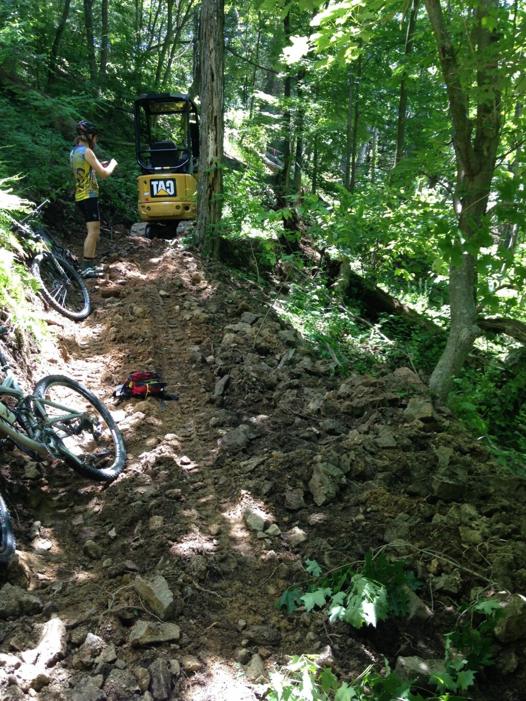
Great question and one that we have heard a lot as of late what with the $80,000 of work that the SVBC orchestrated up on 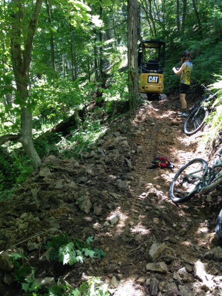
the Carr Mountain Trail as part of the $300,000 spent on National Forest Trails in 2016. Dirt Sculpt from PA won the contract and built the trail for us up on Carr Mountain. Like what we are doing? then please consider DONATING TODAY to help us keep doing awesome things with trails in Virginia! or Learn more about all of our amazing projects in 2016 to improve our National Forest.
A little backstory: The Carr Mountain Trail is part of the Great Eastern Trail and the Virginia Mountain Bike Trail. 2011 Post about the Carr Mountain Trail on SVBCoalition.org & 2012 SVBCoalition.org post about the Carr Mountain Trail
Location: Carr Mountain is in the lost and forgotten corner of Rockingham County just south of Bergton and Criders. It is deep in the “Bermuda Triangle of Fireroads,” So be sure to take a map and, ideally your phone with
Maps: You will want the National Geographic Trails
Illustrated Map for Massanutten & Great North Mountain Map #792(you can find this at any local bike shop) Also a good idea to download PDF maps for your smartphone. With PDF maps you can and should purchase the National Geographic maps and then see your location in real-time on the National Geographic Trails Illustrated Map. PDF maps also works when you don’t have cell phone reception.
Driving Directions: Follow this Google Map Driving Directions to Blue Hole near Bergton. Should take about 45 minutes from Downtown Harrisonburg. Park at Blue Hole (not the one on US 33) but instead near Bergton
 Riding Directions Option 1 Recommended first try route (Out and Back): Park at Blue Hole and follow Forest Service road # 302 all the way up towards White Grass Knob. Be careful not to make any wrong turns down road # 302A, 302B, or 302E Because of recent logging, 302B will look like it has much more traffic than 302, but it does NOT climb up to Whitegrass Knob. For this reason, it is a good idea to use PDF maps so you can see where you are (pdf maps work even when you don’t have cell reception). If you make all the proper turns, the road will end at the new trail build (it should be about an hour climb from your car). You will climb up the new build and can go in as far as you would like before turning around to ride back to your car. The new build is several miles but the trail goes all the way back to German River Road in a much more primitive state.
Riding Directions Option 2 NOT recommended unless you have already ridden option #1(Loop Ride): Park at Blue Hole and ride out to Bergton proper and at the Bergton store and post office, turn left and head towards Criders on 826 and once at Criders, turn left onto German River Road. Never mind the no trespassing signs that you may see but do be sure to remain ON the ROAD. You will quickly be on National Forest property and will be nearly paralleling the Carr Mountain Trail that is up on the ridge to your left.
Intersection with German River Road and the Carr Mountain Trail. It is NOT marked until you get up and over the tank traps. Then you will see the blazes and singletrack
Continue on German River Road for a bit over 6 miles. This is the part that is hard to find. You need to find the southern terminus for the Carr Mountain Trail. It will be shortly after you cross under large high transmission power lines that you will likely miss. It is BEFORE you come to a three-way intersection complete with a river crossing. It meets the road at an angle and is a STEEP grade doubletrack used to access the power line. Once you climb up it and over some tank traps, you will then see the proper trailhead on your left. Here is a photo of the intersection on German River road. This is looking north on German River road.
Once you are on the Carr Mountain Trail, you will have about 6 miles of trail before you connect back with Forest rd #302. Your first several miles of the Carr Mountain Trail may be a bit hard to follow from time to time. You can see a GPX track of the trail on this Strava ride: Carr Mountain but DON’T go down Low Place Rd. Be sure to make all the proper turns to remain on Forest rd 302 Lair’s Run road to get back to your car at Blue Hole. BRING A MAP!
10 Responses
There is another way to the Carr Mtn. trail head.
Take Snake Hollow Rd. which is left off German River Rd about 1 mile out of Criders,. This is a gravel road that runs for about 3 miles to White Grass Knob. You can park at Criders, or 400 yds. up Snake Hollow, or 2 miles up Snake Hollow at the closed gate. A high clearance vehicle is probably a good idea for the latter. At the top of this road is half a mile of single track, rideable by some people, which goes around White Grass Knob and then drops down to the end of the Blue Hole Rd where the Carr Mtn trail begins. The single track has some yellow blaze marks, but at the end where it takes a left to drop down to Blue Hole Rd. is currently a little obscure.
For the new construction the trail runs 3-4 miles, followed by about 3 miles of older single track which will drop you down to German River Rd. via a short double track section. From there it is a fun, mostly downhill, ride on German River Rd back to Criders, about 8 miles.
From Criders, the loop I have described is about 19 miles, with 2900 ft of gain/loss of elevation, and should take about 3 hours.
Note that from Blue Hole it is about 7 miles of mostly climbing to the start of the Carr Mtn trail.
Thanks Andy. We have made that connection before but I don’t want to send your average rider there given the challenge of making the Snake Hollow to Carr Mountain Connection. I agree that this route takes out a lot of the road and makes for a shorter loop. I hope you enjoyed the new trail!
Here is a GPS track for the loop (option 2):
https://ridewithgps.com/routes/17302624
Super fun ride, even the first few miles of pavement are not bad given the views. The first half of the single track is old school trail, then you get to the new build to finish the climb followed by a downhill ripper. Huge thanks to SVBC for this project!
And here is a GPS track for the Snake Hollow option. A bunch of climbing in 18 miles!
https://ridewithgps.com/routes/17556513
What’s the scoop on camping nearby?
You can camp most places on National Forest Land. There aren’t any developed campgrounds really close to Carr Mountain. Slate Lick area is a popular place for some folks to camp.
I was told this trail is not rideable any more, due to disuse and overgrowth. Do you know if this is true? Has anyone ridden it lately?
We haven’t been out on the trail personally in a few years now. It is likely rideable for a another week or two before the spring/summer growth begins. But don’t take our word for it.
We cleared most of the trees off the path yesterday. There is still a lot of briars (my legs are carved up). It’s easy to get lost but well worth trip (the views are amazing). The other catch is the leaves – they are deep and make peddling tough. This is NOT an easy trek.
Did you pedal down German River Road? From the north there is a sign stating that the road is private, and it appears from maps there is a closed gate on the road. Seeking information on how easy it would be to access the Carr Mtn Trail southern terminus from German River Road via a 4Runner.